Atmospheric rivers provide vital source of water for the West

Atmospheric Rivers

(The news article was published in NEWS@TheU on October, 28, 2021, interview with Prof. Ben Kirtman by Janette Neuwahl Tannen)

Meteorologist and professor of atmospheric sciences Ben Kirtman explains how these ribbons of water vapor in the sky affect the climate of California and the Pacific Northwest.

Atmospheric rivers. Until the deluge of record-setting rain and storms that inundated California and the Pacific Northwest earlier this week, many people were probably unfamiliar with the term.

To be fair, the atmospheric river that overwhelmed the West Coast last week didn’t act alone. It also collided with a bomb cyclone before coming onshore on Sunday, unleashing strong winds and record-breaking rain in the San Francisco Bay area, and snow, mudslides, and power outages in a region still recovering from a very active wildfire season.

But the extreme weather left many wondering: what are atmospheric rivers, and what do they do?

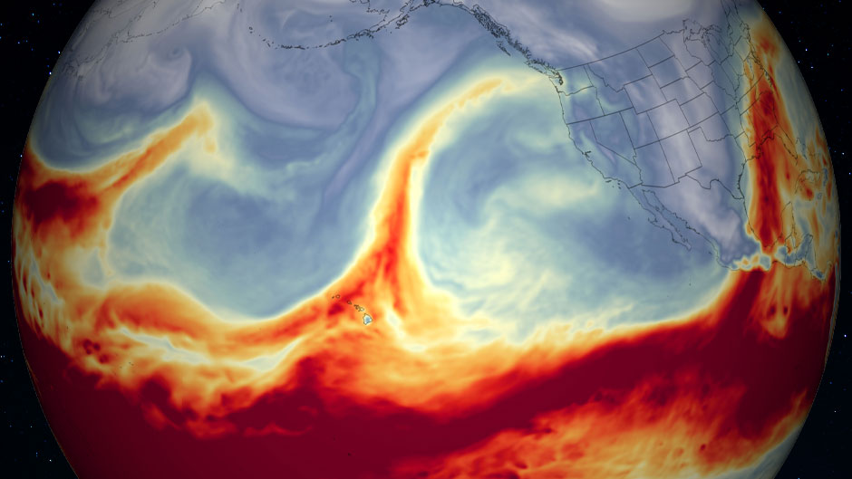
Atmospheric rivers are tubes or ribbons of water vapor that evaporate from the equator and surge up into the atmosphere over the ocean, flowing toward the poles, according to meteorologist Ben Kirtman, professor of atmospheric sciences at the University of Miami Rosenstiel School of Marine and Atmospheric Science. Although a few head toward the South Pole, the majority meander from the southwest to the northeast. In the Pacific Ocean, this means they head toward the western coast of the United States, and in the Atlantic Ocean, they drift up toward western Europe.

Discovered in 1992 by a team of meteorologists, atmospheric rivers serve as a pathway for moisture to move around the globe. And they contain as much water as 25 to 30 Mississippi Rivers, Kirtman said. They also provide up to 50 percent of California’s annual rainfall, so atmospheric rivers are important climatically, as well as locally.

“There are maybe four to six atmospheric rivers around the world at any one time and they cover about 10 percent of the surface area of the globe,” said Kirtman, who also directs the Cooperative Institute for Marine and Atmospheric Studies. “But they actually produce 90 percent of the transport moisture from the deep tropics to the mid-latitudes.”

Since atmospheric rivers are typically most active in the winter, they also coincide with other climate patterns that can impact global weather—the El Niño/La Niña effect. These phenomena can have a major influence on the number of atmospheric rivers that develop, Kirtman said. Currently, meteorologists believe we are experiencing a La Niña pattern for a second consecutive year. La Niña years are typically characterized by less rainfall and more drought conditions, which means winters in the southern half of the United States are drier and often warmer. In contrast, the upper half of the country experiences more precipitation, cooler temperatures, and fewer atmospheric rivers during a La Niña winter.

Here, Kirtman elaborates on the characteristics of atmospheric rivers, and explains how La Niña and climate change could impact them.

Are atmospheric rivers coming ashore predictable weather events? What about bomb cyclones?

We knew about this storm developing several days in advance. And we knew over a week ago that this atmospheric river and cyclone would come together [from the satellites and models]. So as a weather event, we can predict both atmospheric rivers and cyclones five to seven days ahead of time, and we knew this was going to be a big event because we could see these two disturbances would likely come together at just the right time.

Then, two to four weeks in advance, if there’s a phenomenon called the Madden-Julian Oscillation, and if that is in the right phase, we know statistically that there are more atmospheric rivers. So, we can say two to three weeks in advance that there is an increased chance of atmospheric rivers coming ashore.

How might the La Niña climate pattern impact the number of atmospheric rivers coming ashore this winter?

This one storm exemplifies an interesting aspect of the El Niño/La Niña trends. If you look at the winter season, which is when atmospheric rivers tend to be more prevalent, it is also when we have El Niños happen, which typically produce more atmospheric rivers in the winter.

However, this year is a reasonable La Niña, which usually produces less atmospheric rivers in the winter. But when you look at a whole year, there are actually more overall atmospheric rivers in a La Niña year. So, this particular event was outside of the deep winter (which is January through March) and shows that you can have quite a lot of atmospheric rivers hitting the west coast of U.S., even in a La Niña year.

Does this first strong storm signal more atmospheric rivers for the West Coast this winter?

We can’t say that. In fact, for this coming winter, the forecast is 60 to 70 percent chance of below average rainfall for most of southern and central California, and there’s a 60 percent chance of above average rainfall in Oregon, Washington, and western Canada.

Do atmospheric rivers often coincide with bomb cyclones, like this one did?

No. Atmospheric rivers do not always come onshore with a bomb cyclone. In fact, you can have an atmospheric river come ashore and not much rainfall happens, but this one happened to occur with a bomb cyclone and that’s why it created so much rain.

Climatologically speaking, there are anywhere between zero and two of these combination events per winter season off the west coast of North America.

Is this the worst cyclone/atmospheric river collision you have seen?

No. The worst one I recall was an atmospheric river and cyclone colliding in January of 2018 that led to serious mudslides in Montecito, California, near Santa Barbara, and a number of people died. Our multi-model Subseasonal Experiment forecast project (SUBX) actually predicted that event three weeks in advance.

How will climate change affect these atmospheric rivers?

As climate change continues to impact the earth and our weather heats up, one thing we are confident about is that the atmosphere will have more moisture in it. So these atmospheric rivers will lead to more extreme rainfall. And, as these atmospheric rivers are fueling bomb cyclones with even more moisture, they are likely to bring even more rainfall. We can also expect more localized extreme flooding associated with these atmospheric rivers. There’s still a lot to learn though, and the research in this area is exploding for many reasons.

On the other hand, there are also some signals in climate change research that we may get less atmospheric rivers overall. This relies on the strong contrast between the equator and poles that is waning through time, but this process is not well understood yet.

With climate change, will we also see more cyclones affecting both coasts of the U.S.?

There’s evidence that there may be more extreme cyclones, but I don’t know if we can say with confidence that they are more frequent. It’s like hurricanes. We don’t have good evidence that hurricanes will become more frequent now, but we will have more intense hurricanes. The intensity of these storms is expected to increase because of warming sea surface temperatures, which means there’s more moisture in the atmosphere, as well as a number of different factors.

What kind of research is being done about atmospheric rivers?

Meteorologists are interested in creating early warning systems for these events, to help save lives.

Overall, in the west there is less total rainfall during La Niña, so they are having longer dry seasons now. Then, when you have one of these atmospheric rivers come, that intense rainfall over a short time often leads to mudslides, so there are a lot of ancillary risks associated with extreme rainfall. Yes, California is in a severe drought now, and it needs water. But the drought has also led to fires, which removes vegetation that holds dirt on the mountainside, so when you get mudslides, people can die. So, there are lots of risks. If you can have an earlier warning system, then municipal leaders and emergency managers can start thinking about what their city or town can do to deal with potential mudslides. These are things you can plan for, put in infrastructure for, and warn people to move out of the way if you have that time. So, there’s a lot of interest in trying to predict these extreme events on relatively short time scales as weather events, and then farther out to do some serious planning several months before.

(by Janette Neuwahl Tannen)